
- Number 332 |
- March 7, 2011
INL's unmanned aircraft survey landscape, focus on environment
Small robotic airplanes
carrying sophisticated visual
sensors can help scientists
quickly and efficiently
monitor the health of large
ecosystems.
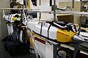
Robotics and remote sensing experts at DOE's Idaho National Laboratory have added state-of-the-art imaging and wireless technology to Arcturus T-16 unmanned aerial vehicles, or UAVs, to create intelligent remote surveillance craft that can rapidly survey a wide area for damage or security threats.
The planes' latest mission is to carry Resonon's compact Pika hyperspectral sensors to "read" the health of the environment on a much larger scale than is practical with ground-based sensors. By adapting the sensors to work on small, computer-controlled planes, INL researchers have made airborne hyperspectral sensor technology significantly cheaper and easier to deploy on demand.
High-flying cameras and sensors have been used since the 1970s to study the Earth's surface, revealing clues about the condition of vegetation and wildlife, and the presence of nutrients and pollutants. For much of 2010, for example, NASA's AVIRIS hyperspectral sensor has been mapping and analyzing the Gulf of Mexico oil spill. But AVIRIS is often booked more than a year in advance, it's expensive to deploy, and its tight schedule means that bad weather or technical hiccups can delay a mission for months or even years. Unlike AVIRIS, UAVs are available on demand to fly for up to16 hours. UAVs can also fly for longer on less fuel than a bigger plane, and the bird-sized UAVs are much cheaper to operate.
Better than a bird's-eye view
Arcturus T-16s more or less fly themselves; all the human pilot has to do is program in a flight path and monitor the plane in the air.
As the T-16 flies in a straight line, the sensor captures one row of pixels at a time, like a scanner scanning a photo, but delivering many times more information about each pixel than a photograph would. While a digital camera's color sensor detects only three colors, the Pika sensor detects light at 80 different wavelengths.
Sensor data is turned into a graph. Since different materials reflect and absorb different amounts of light at each wavelength, the characteristic spectral signatures of healthy plants, soil and oil allow scientists to recognize features in the graph that can be used to detect plant stress or oil pollution.
The T-16-mounted sensor's relatively high spatial resolution could help scientists swiftly analyze entire vegetation systems at the level of individual plants – an unprecedented combination of detail and speed.
Where the deer and the antelope graze

Hyperspectral information
from the UAV can be used
to study the health of plants
and ecosystems on a
wide scale.
The nearly 900-square mile INL site is a refuge for rare animals that depend on sagebrush for food and shelter. Knowing where the healthiest plants are can help scientists predict grazing patterns and direct future development to minimize impact on wildlife.
Meanwhile, the Federal Aviation Administration is in the process of developing new regulations for operating unmanned aircraft. INL's UAV and sensor team won't sit idle while the FAA finalizes its new regulations. The team is rounding up collaborators and funding to help test the UAV-mounted hyperspectral sensor on another, completely different patch of vegetation far from the INL sagebrush steppe.
Submitted by DOE's Idaho National Laboratory