
- Number 381 |
- February 4, 2013
Containing cotton-ball clouds
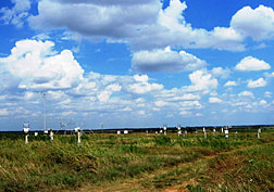
Cotton-ball-like cumuli cloud effects are
now captured in a regional climate model.
Photo courtesy of the U.S. Department of
Energy’s Atmospheric Radiation
Measurement (ARM) Climate Research
Facility.
The large impact of the small, fair-weather clouds on the amount of sunshine reaching Earth's surface is now more accurately modeled, thanks to scientists at DOE's Pacific Northwest National Laboratory. The team's new method includes variations in temperature and humidity near the surface and their role in forming these clouds. Their method improves climate forecasts and yields better cloud predictions, including the amount of sunshine the clouds reflect.
Looking like stretched-out cotton balls, these common clouds reflect the sun's energy back to space. Because they are so small, researchers have not been able to track their reflecting properties with global or regional climate models. Improved understanding of the impact of these clouds will provide scientists with more detailed information on weather and climate that was frequently misread.
"Our ‘model grid box' is like a large fish net," said PNNL's Dr. Larry Berg, lead scientist. "Previously these puffy, fair-weather clouds, like small fish, fell through the netting and were never caught. With this new method, that is no longer the case."
The DOE Office of Biological and Environmental Research's Atmospheric Systems Research program funded the study. The DOE Atmospheric Radiation Measurement Climate Research Facility provided the data. Environmental Molecular Sciences Laboratory provided computer resources.[Kristin Manke, 509.372.6011,
kristin.manke@pnnl.gov]