
- Number 386 |
- April 15, 2013
Rivers run right through...the model
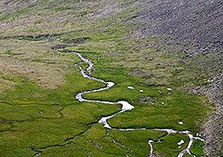
The new river-routing model can simulate
how water makes it into tributaries and the
main river channel through its pathways as
surface runoff and subsurface water
discharge that you can’t see.
Because climate change, hydropower dams, and reservoirs greatly influence water sources, scientists at DOE’s Pacific Northwest National Laboratory built a river-routing model, known as MOSART, to help with water management. The full name of MOSART is the MOdel for Scale Adaptive River Transport. MOSART helps scientists improve computer simulations of the magnitude and timing of water flow through the landscape and into the ocean. This new tool is better at simulating water flow at different scales than some widely used large-scale routing models. By coupling MOSART with established land and Earth system models, scientists will better understand a wide range of water-land-climate interactions. Thus, MOSART serves as a cornerstone for integrating and understanding the impacts of human activities on the water cycle at regional and global scales.
Designed to work within the smaller regional modeling units or the larger global ones, MOSART first tracks the surface water routes along the land surface. Then, it collects water discharged from the surface and subsurface systems into tributaries before entering the main river channel.
The team tested MOSART on a large river basin at different spatial resolutions and evaluated their model output using physical measurements of stream flow. Their results compared well with consistent performance at multiple resolutions. The team also compared the model of field measurements of water velocities in small channels. The results showed MOSART could produce seasonal variations in water storage and velocity in channels at different resolutions.
The team at PNNL is conducting further studies based on MOSART. They have incorporated MOSART into the Community Land Model and are testing it at the continental and global scales. In addition, they developed and are testing a reservoir operation model built on MOSART and are coupling the modeling suite to the integrated assessment model Global Climate Assessment Model, developed at PNNL and funded by DOE’s Office of Science.
This work was supported by DOE’s Office of Science Earth System Modeling and Integrated Assessment Research Programs through the Integrated Earth System Modeling and Climate Science for Sustainable Energy Future projects. Development of the datasets used in this study was partially supported by the Platform for Regional Integrated Modeling and Analysis initiative, a PNNL Laboratory Directed Research and Development program. In addition, some data and information were provided by the Surface Hydrology Group, University of Washington.[Kristin Manke, 509.372.6011,
Kristin.manke@pnnl.gov]