
- Number 429 |
- December 22, 2014
Fast and rigorous: Finding surface reflectivity by looking up at clouds
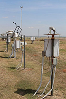
The Multifilter Rotating Shadowband
Radiometer and other instruments help
scientists understand the amount and type
of light that hits Earth’s surface. Photo
courtesy of the ARM Climate Research Facility.
Understanding climate change begins with measuring important energy factors affecting the Earth. One of these factors is the amount of sunlight reflected by the Earth's surface. The surface's reflectivity or surface albedo—a measure of how mirror-like the Earth's surface is—greatly influences the amount of sunlight coming into and leaving the atmosphere. Researchers at DOE's Pacific Northwest National Laboratory developed a new way to measure surface albedo by capturing sunlight bounced back to Earth by the clouds. With scientists from the National Oceanic and Atmospheric Administration and University of Colorado, the researchers showed how the method has potential for capturing the surface albedo.
"Previously, retrieving surface albedo from incoming sunlight measurements required substantial computational power and complementary information that was often limited or unavailable," said Dr. Evgueni Kassianov, the study's lead author. "Our method is based on a one-line equation and is simple, fast, and requires only a few inputs."
Previous methods often relied on conventional tower-based instruments, but these are limited to several well-established sites. Moreover, tower installations are expensive and more important, instruments mounted on towers can only measure the reflectivity of a small area near the base of that tower. These local measurements may not represent a larger area, something that is of most significance for climate studies.
Instruments that look up toward the sky–used to measure incoming sunlight energy–are deployed at diverse locations with differing surface properties. The team's new method can calculate the areal-average surface albedo–that is, a larger surface area–at these locations. This measurement is exactly what is needed to validate and improve large-scale models. This research was funded by DOE Office of Science, Office of Biological and Environmental Research, Atmospheric Radiation Measurement (ARM) Climate Research Facility. Next, the team plans to extend the new method to key ground-based instruments for improved estimates.[Kristin Manke, 509.372.6011,
kristin.manke@pnl.gov]