
- Number 431 |
- January 26, 2015
On the right track for tropical clouds
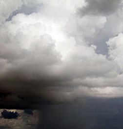
Large-scale vertical lifting and the decline
of mid-level drying are vital to initiating and
propagating MJO deep convection.
Photo courtesy of Adam H. Sobel,
The Madden-Julian Conversation.
Think of a tropical storm about the size of Alaska. Large and lumbering, the Madden-Julian Oscillation (MJO) affects weather patterns in every corner of the world. Unlike its well-known cousin El Niño, the MJO is both variable and unpredictable, earning the title of the largest and least understood element in the tropical atmosphere. However, scientists at DOE's Pacific Northwest National Laboratory and collaborators at the Indian Institute of Technology recently discovered what forces cause the MJO to begin and keep moving. Understanding the MJO could allow accurate weather forecasts beyond 10 days, enabling better prediction of severe storms.
The team began with data collected during the ARM MJO Investigation Experiment (AMIE)/Dynamics of the Madden-Julian Oscillation (DYNAMO) field campaigns. The campaigns took place in the winter of 2011 over the Indian Ocean. With this data, they ran high-resolution regional model simulations.
They tracked thousands of clouds that constitute this weather system to their origins and documented the environmental factors that lead to their growth. They found that just before the abrupt initiation of the system, moisture is transported from the surface of the ocean to the atmosphere and the transport of dry air, unfavorable for the growth of the clouds, is suppressed. These two events conspire to initiate this large weather pattern.
The MJO normally starts over the Indian Ocean and circumnavigates the world eastward in about 30 to 60 days, moving at about 10 miles per hour. The MJO’s frequency of storm-forming clouds, that transition from dry shallow clouds to deep, rain-rich clouds, is responsive to how moisture builds up in the lowest portion of Earth’s atmosphere. Further, it is sensitive to larger-scale atmospheric lifting forces that draw moisture out of the tropical ocean. Knowing the triggers that lead to the MJO will help better predict when it will occur.
Sponsors: The research is supported by the U.S. Department of Energy Office of Science's Office of Biological and Environmental Research under the Atmospheric System Research Program, and the Regional and Global Climate Modeling Program.
Facility Involvement: Oak Ridge Leadership Computing Facility through the INCITE Climate End Station project, National Energy Research Scientific Computing Center, and the ARM Climate Research Facility.[Kristin Manke, 509.372.6011,
kristin.manke@pnnl.gov]